Predicting Satellites’ Visibility

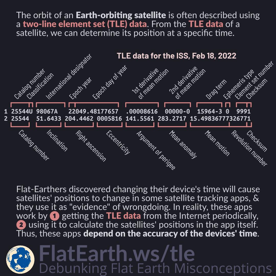
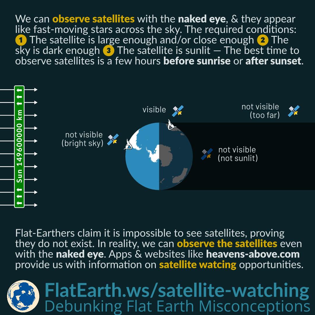
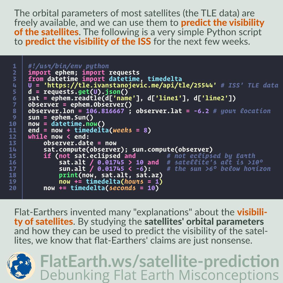
The orbital parameters of most satellites (the TLE data) are freely available, and we can use them to predict the visibility of the satellites. The following is a very simple Python script to predict the visibility of the ISS for the next few weeks.

Flat-Earthers invented many “explanations” about the visibility of satellites. By studying the satellites’ orbital parameters and how they can be used to predict the visibility of the satellites, we know that flat-Earthers’ claims are just nonsense.

Continue reading “Predicting Satellites’ Visibility”

Galilean Moons: First Objects Observed to Orbit Another Object

Featured Video Play Icon

Jupiter has four moons (Io, Europa, Ganymede, & Callisto) that we can easily observe using a binocular or telescope. They are the first objects found to orbit another, proving it is possible for a satellite to orbit planets other than Earth.

Flat-Earthers like to demand evidence of an object orbiting another. All they have to do is use a telescope to observe Jupiter. Its moons have short orbital periods (1.8 to 16.7 days), & thus, it is not hard to observe the orbiting motion.

Continue reading “Galilean Moons: First Objects Observed to Orbit Another Object”

Overlay in Geographic Information System (GIS)

In geographic information system (GIS), overlay is an operation that superimposes layers of geographical data —like maps, satellite photos, roads, borders, etc— on top of each other.

Some satellite photos of Earth at night show country borders and shorelines. Flat-Earthers use the fact to dismiss the images as fake. They claim there are no lights illuminating the border on the ground, therefore the borders should not be visible. In reality, the borders are just an overlay added on the top of the original image. They are not part of the original satellite image.

Continue reading “Overlay in Geographic Information System (GIS)”

Satellites in Earth’s Photos

A satellite’s size is as small as a mobile phone to as large as a football field. The largest is 109 m, still far too small compared to Earth at 2742 km in diameter.

Satellites are not visible in Earth images. Flat-Earthers use the fact as “evidence” of deception. In reality, satellites are tiny compared to Earth. They are invisible in Earth images the same way ants are not visible in images of a football field.

Continue reading “Satellites in Earth’s Photos”

Satellite Tracking Apps and the Two-Line Element Set Data (TLE)

The orbit of an Earth-orbiting satellite is often described using two-line element set (TLE) data. From the TLE data of a specific satellite, we can determine its position at a certain time.

Flat-Earthers discovered that changing their device’s time will cause satellites’ positions to change in some satellite tracking apps, and they use it as “evidence” of wrongdoing. In reality, these apps work by getting the TLE data from the Internet periodically and then using the data to calculate the satellites’ positions in the app itself. Therefore, these apps depend on the accuracy of the devices’ time.

Unlike what these flat-Earthers imagine, these apps do not work by receiving telemetry data from the satellites in real-time.

Continue reading “Satellite Tracking Apps and the Two-Line Element Set Data (TLE)”

Multiple Exposure Photos of Balloons and SpaceX StarLink Satellites

To monitor the ozone hole, NOAA launches a balloon every week on several locations on Earth. Scientists who launch the balloons like to create multiple exposure photos of the event. A single balloon appears multiple times in the resulting photos.

Flat-Earthers saw the “many balloons in a row” photos, & they incorrectly use them as the “explanation” of the appearance of the SpaceX Starlink satellites. In reality, the photos are just multiple exposure photos. There is only a single balloon, but taken multiple times and then merged into a single photo.

Continue reading “Multiple Exposure Photos of Balloons and SpaceX StarLink Satellites”

How Satellites Can Orbit and Stay Up There

Earth’s gravity pulls things toward Earth. Satellites can stay up there because they are orbiting. They are moving at the right speed and right direction to counter the pull of gravity.

Flat-Earthers claim that satellites should fall down if gravity pulls toward Earth. In reality, we do not just launch satellites to space. We also give them the correct speed & direction, so they neither fall toward Earth nor keep going farther away.

Continue reading “How Satellites Can Orbit and Stay Up There”

Google Street View

Flat-Earthers noticed “mysterious” wandering vehicles with a Google branding and strange equipment mounted on them. They use the fact as “evidence” that Google Maps does not use satellites to obtain the images. In reality, these vehicles record images for Google Street View. It is impossible for street-level
vehicles to obtain the aerial images used by Google Maps.

Continue reading “Google Street View”

Cellular Network Backhaul

In cellular telecommunications, backhaul is the connection between a base transceiver station and the core network. The means of the connection can be anything, including cable, fiber optic, microwave links, and satellite links.

Flat-Earthers use the fact that cell phones communicate with base stations as “evidence” satellites do not exist. In reality, some cellular companies do utilize a satellite for backhaul purposes, especially for stations in remote, isolated areas.

Continue reading “Cellular Network Backhaul”

Satellite Watching

We can observe satellites with the naked eye, and they will appear like fast-moving stars across the sky. The required conditions: the satellite is large enough and/or close enough, the sky is dark enough, and the satellite is lit by the sun. As a result, the best time to observe satellites is a few hours before sunrise and a few hours after sunset.

Flat-Earthers claim it is impossible to see satellites and use the fact as “proof” the satellites do not exist. In reality, we can observe the satellites even with the naked eye. Apps and websites like heavens-above.com provide us with information on satellite watching opportunities.

Continue reading “Satellite Watching”

Why It is Difficult for Satellites to Locate the Missing MH370 Flight

If many satellites provide navigation and surface imagery, why is it challenging to locate the missing MH370 flight?

Satellite navigation, including GPS, is passive. Satellites emit signals, which are processed by receivers —including those on board the MH370— to determine their own locations. The satellites never receive anything from MH370 and cannot determine its location.

Airliners do broadcast their positions using ADS-B. However, at the time of MH370, only ground-based ADS-B stations existed. There were no satellite-based ADS-B receivers yet, and no coverage in the middle of oceans.

Continue reading “Why It is Difficult for Satellites to Locate the Missing MH370 Flight”

Cellular Network vs Satellite Communications

A cellular network consists of several cells. Each of the cells is serviced by a base station operating with a specific frequency. Adjacent cells are each assigned a different frequency. A non-adjacent cell will be able to use the same frequency without interfering.

Flat-Earthers like to tell us that a single satellite can cover an entire country, yet phone operators choose to install base stations everywhere instead. Then they use the fact to “prove” that satellites do not exist. In reality, a cellular network has several advantages compared to one single base station, like a satellite.

Continue reading “Cellular Network vs Satellite Communications”

Sun Outage

A Sun outage is a disruption of geostationary satellite signal caused by interference of the sun when it falls directly behind a satellite with which a receiver is communicating. Sun outages occur around the March equinox and September equinox.

Flat-Earthers fail to understand how the schedule of a Sun outage depends on the satellite and the receiver’s location. And they use it to discredit the fact. In reality, it is not difficult to visualize how a Sun outage occurs, and it will be consistent with the expectation.

Continue reading “Sun Outage”

Orbit of DSCOVR Satellite

The DSCOVR satellite orbits around the Lagrangian point L1 between the Sun and Earth. We can say the DSCOVR satellite lies between the Sun and Earth, but it is not exactly between them.

Flat-Earthers discovered images taken by the DSCOVR satellite showing the Moon in front of Earth and a solar eclipse shadow on Earth’s surface. Then they concluded it should be impossible if DSCOVR is really between the Sun and Earth. In reality, the DSCOVR satellite is not exactly between the Sun and Earth. It orbits a point between the Sun and Earth.

Continue reading “Orbit of DSCOVR Satellite”

Frame of Reference

A frame of reference consists of an abstract coordinate system and physical reference points that uniquely fix the coordinate system and standardize measurements. Speed or velocity is relative to a specific frame of reference. It is possible that two speeds/velocities are measured relative to a different frame of reference and thus cannot be directly compared.

Flat-Earthers like to compare two different speed measurements like an airplane moving at 900 km/h (560 mph) and Earth’s surface near the equator at 1674 km/h (1040 mph). They would conclude the airplane should not be able to catch up with Earth’s surface and would not land if the Earth is rotating. In reality, both the speeds are measured relative to a different frame of reference, and therefore, cannot be compared directly.

Continue reading “Frame of Reference”

Lunar Transit Images from DSCOVR-EPIC

Featured Video Play Icon

DSCOVR is a spacecraft positioned in the Lagrangian point L1 between the Sun and Earth. It carries the EPIC camera that continuously takes images of Earth in 10 wavelengths from 317nm to 780 nm in rotation.

The Moon can appear in EPIC images, and flat-Earthers incorrectly use the color fringing around the Moon to dismiss the images as fake. In reality, the full-color images are composite of three single-color images taken in consecutive exposures in a one-minute span. As a result, the Moon had shifted in the time span and not perfectly aligned in the different exposures, causing the color-fringing after the images are composited together.

Continue reading “Lunar Transit Images from DSCOVR-EPIC”

How Rocket Engines Work in A Vacuum

Featured Video Play Icon

Rocket engines produce thrust by releasing mass rearward at a very high speed according to Newton’s third law, not unlike how discharging a fire extinguisher pushes us backward.

Flat-Earthers claim that rocket engines cannot possibly work in space because space if vacuum and there is no air to push against. In reality, it is possible to produce thrust in a vacuum by releasing mass —that we call “propellants”— rearward at a very high speed.

Continue reading “How Rocket Engines Work in A Vacuum”

Newton’s Cannonball

Featured Video Play Icon

Newton’s cannonball was a thought experiment Isaac Newton used to explain the principle of orbital motion. It was the first explanation of an orbit and still the easiest to understand.

Newton visualizes a cannon on top of a very tall mountain where the air resistance is no longer a factor. As more charge is used with each cannon shot, the speed of the cannonball will be greater, and the cannonball will hit the ground farther and farther. Finally, at a certain speed, it will not hit the ground at all. It will fall toward the spherical Earth just as fast as the Earth curves away from it. In the absence of drag from the atmosphere, it will continue forever in orbit around the Earth.

Continue reading “Newton’s Cannonball”

Usage of Animation to Visualize Space Missions

Many space missions use animations to visualize the state of the missions because it is impossible to record a video of the event. Spacecrafts continuously send telemetry data to Earth informing the status of their mission, and from the data, an animation can be constructed to illustrate the spacecraft’s current situation.

Flat-Earthers accuse that the animations are “proof” that the missions are faked. In reality, the animations are faithful depictions of the missions and are made to visualize the real state of the mission. Animations are used because it is not viable to send another spacecraft only to record a video of the mission. Furthermore, in the cases where the video is available, it is still too difficult for these flat-Earthers to accept reality.

Location Crowdsourcing

In addition to satellite navigation, mobile phones can also use crowdsourced cell sites and WiFi access points location data. Phones help each other by creating a centralized database of the locations of cell sites and WiFi access points. If satellite navigation is unavailable, then the phones can utilize this database to determine their positions.

Some documentations explain how a phone or device without GPS can determine its location. Flat-Earthers incorrectly use these documentations to “prove” GPS does not use satellites. In reality, there are various methods of determining location, not just GPS. These documentations explain location service using cell & WiFi crowdsourcing, which is different from GPS.

Continue reading “Location Crowdsourcing”