Shooting Distance and the Magnitude of the Coriolis Effect

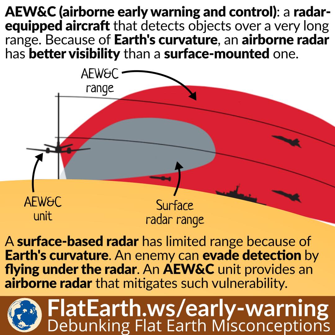
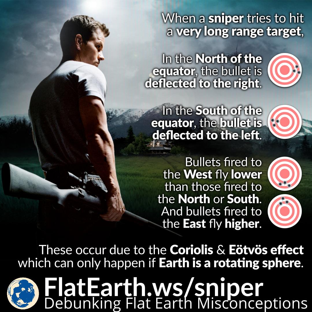
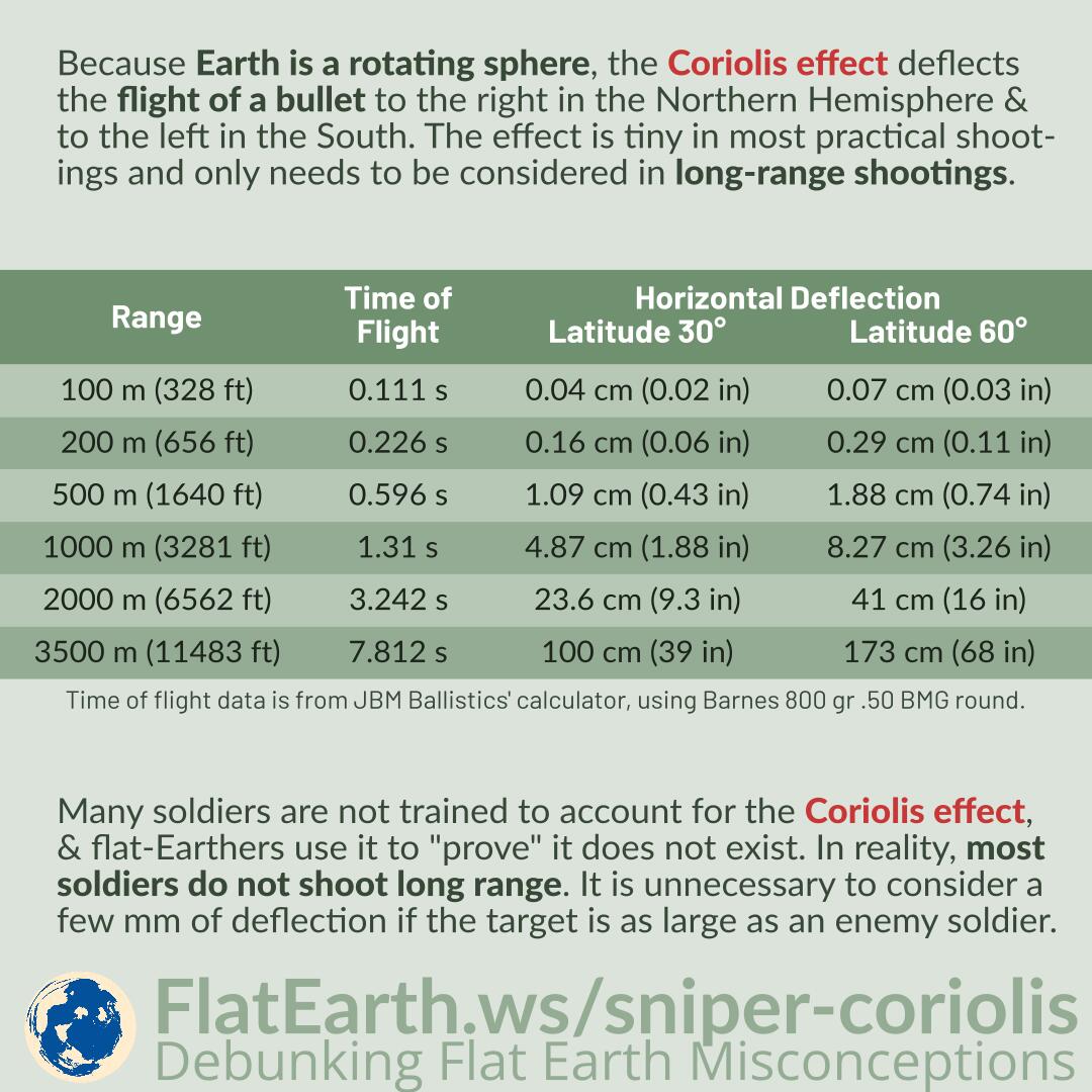
Because Earth is a rotating sphere, the Coriolis effect deflects the flight of a bullet to the right in the Northern Hemisphere & to the left in the South. The effect is tiny in most practical shootings and only needs to be considered in long-range shootings.

Many soldiers are not trained to account for the Coriolis effect, & flat-Earthers use it to “prove” it does not exist. In reality, most soldiers do not shoot long range. It is unnecessary to consider a few mm of deflection if the target is as large as an enemy soldier.

Continue reading “Shooting Distance and the Magnitude of the Coriolis Effect”

Earth’s Rotation in Field Artillery Operation Manual

Featured Video Play Icon

The “Field Artillery Manual Cannon Gunnery” (TC 3-09.81) is a manual from the US Army explaining the operation of field artillery. From the manual, we know the operators of field artillery are required to account for Earth’s rotation.

Flat-Earthers wrongly claim that an artillery operator never needs to account for Earth’s rotation. In reality, from this operational manual, we know their claim is incorrect.

Continue reading “Earth’s Rotation in Field Artillery Operation Manual”

Submarine’s Periscope

A periscope is an optical instrument that allows submarine operators to visually observe the situation above the surface while submerged. Like other optical devices, Earth’s curvature can obscure the visibility of a distant object.

Flat-Earthers claim a periscope can see objects that are too far, and they use it to “prove” a flat Earth. In reality, everything is consistent with spherical Earth. A ship 50 m (165 ft) high at a distance of 25 km (15.5 miles) can still be visible if the weather allows & the periscope is 2 m (7 ft) above the surface.

Continue reading “Submarine’s Periscope”

Air Map of the World 1943/1945

Flat-Earthers discovered a map titled “Air Map of the World” from 1943, explaining the flight routes during the time. Because the shape is identical to the fictional “flat Earth map,” they incorrectly claimed that it is a flat-Earth map. In reality, it is an azimuthal equidistant map that has distortions, a flattened shape of the spherical Earth on a flat surface, and does not depict the true shape of the Earth.

The exact nature of the map is even explained in a very detailed manner in the map’s description. Unfortunately, in the flat-Earth community, the map is passed around in a very low resolution, and therefore, the explanations become unreadable.

Continue reading “Air Map of the World 1943/1945”

High-Altitude Nuclear Explosions (HANE)

High-altitude nuclear explosions (HANE) are the results of atomic weapons testing, conducted by the United States and the Soviet Union between 1958 and 1963. In these tests, nuclear warheads were launched and deliberately detonated at a high altitude, between 23 km and 540 km.

Flat-Earthers claim that HANEs were produced by attempts to penetrate the mythical dome enclosing the supposed flat Earth using nuclear weapons. They are wrong. The warheads were deliberately detonated at a high altitude, and the mythical dome does not exist in reality, only in their imaginations.

Continue reading “High-Altitude Nuclear Explosions (HANE)”

Railgun

A railgun is an experimental weapon that uses electromagnetic force to launch high-velocity projectiles. Some railguns are expected to have a range of more than 200 miles.

Flat-Earthers claim that a railgun round always travels straight. And because it can hit targets beyond 200 miles, they use it as “proof” Earth’s curvature does not exist. They are wrong. In reality, railgun rounds are projectiles. The same law of physics that applies to bullets, arrows, or thrown rocks also applies to them. The rounds are affected by air resistance and Earth’s gravity, and will not travel straight for very long. Railguns are capable of hitting targets obstructed by Earth’s curvature and are not proof that Earth’s curvature does not exist.

Continue reading “Railgun”

Laser Guidance

Laser guidance is used by the military to guide a missile toward a target.  A laser designator marked a target by pointing a laser beam at it. The signals bounce off the target into the sky, where they are detected by laser-guided munition, which steers itself toward the center of the reflected signal.

A laser-guided missile can be launched toward a target behind Earth’s curvature. Flat-Earthers claim it proves a flat Earth as it would have been impossible for the launcher to point a laser beam at the target. They are wrong. The laser designator does not have to be the launcher itself. It can be another unit closer to the target, such as infantry or an aircraft.

Continue reading “Laser Guidance”

White Alice and the Troposcatter Propagation

Troposcatter is a signal propagation method using the scattering phenomenon in the upper troposphere. As the signal pass through the upper troposphere, some of the energy is scattered back toward Earth, allowing the receiver station at the correct location to pick up the signal.

White Alice is a decommissioned troposcatter network in North America. Some flat-Earthers invented the “explanation” that the various satellite-based services we enjoy today are using White Alice. They are wrong. White Alice and other troposcatter networks cannot possibly replace all the services provided by satellites.

Continue reading “White Alice and the Troposcatter Propagation”

Range Estimation Using the Distance to the Horizon

Sailors sometimes need to estimate the range of a distant contact. Without radars, the only readily available reference point for estimating ranges is the horizon.

By knowing the height of the observer from the waterline, it is possible to calculate the distance to the horizon, and thus, it is possible to determine the distance to a remote contact, relative to the horizon. It is possible to do this only because the Earth is spherical.

Continue reading “Range Estimation Using the Distance to the Horizon”

Airborne Early Warning & Control (AEW&C): Mitigating Limited Radar Range Due to Earth’s Curvature

An AEW&C (airborne early warning and control) system is a radar system attached to an aircraft. It can detect objects at a very long range compared to any surface mounted radar system.

The reason is that Earth’s curvature limits the range of a surface-based radar. An airborne radar system mitigates this problem.

Continue reading “Airborne Early Warning & Control (AEW&C): Mitigating Limited Radar Range Due to Earth’s Curvature”

Long-Range Snipers and the Coriolis & Eötvös Effects

When a sniper shoots a long-range target, if he is in the northern hemisphere, the bullet is deflected to the right. Conversely, if he is in the southern hemisphere, the bullet is deflected to the left.

The phenomenon occurs because the Earth is spherical and rotating.

Continue reading “Long-Range Snipers and the Coriolis & Eötvös Effects”