The Polar Azimuthal Equidistant Map is NOT the Flat Earth Map

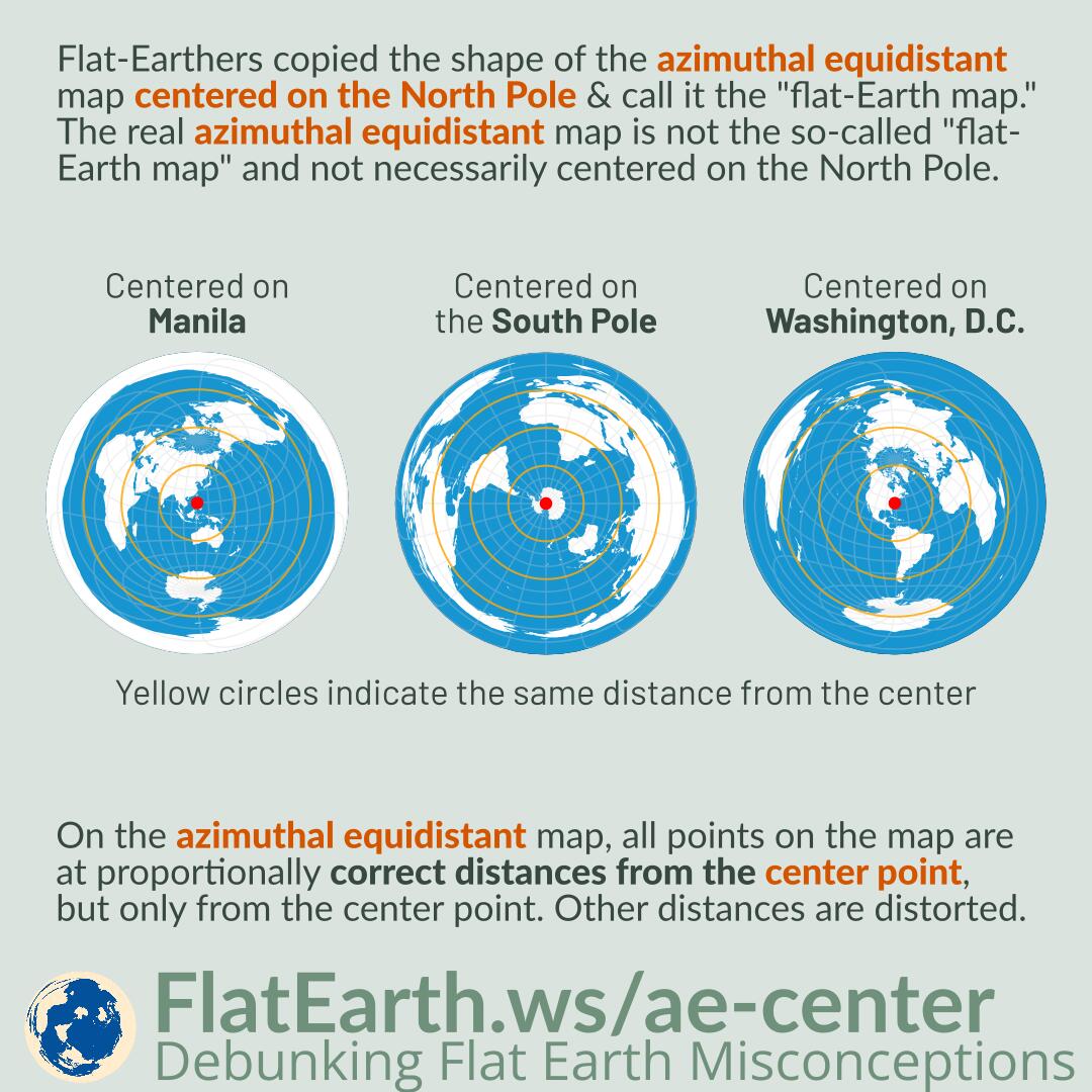
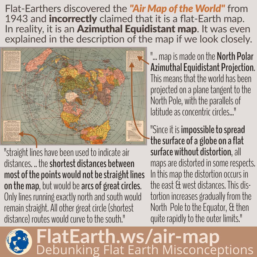
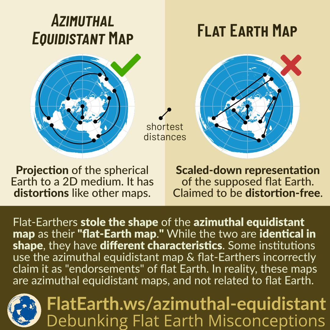
The azimuthal equidistant map is a projection of spherical Earth on a two-dimensional medium. The map has distortions, like every other type of map.

Flat-Earthers stole the shape of the azimuthal equidistant map and call it the “flat-Earth map.” While the two are identical in shape, they have different characteristics. The map that they call the “flat Earth map” is claimed to be a scaled-down representation of the supposed flat earth. They claim it to be distortion-free.

Some institutions use the azimuthal equidistant map & flat-Earthers incorrectly claim it as an “endorsement” of flat Earth. These maps are azimuthal equidistant maps and not related to flat Earth.

Continue reading “The Polar Azimuthal Equidistant Map is NOT the Flat Earth Map”

Astrolabe

An astrolabe is a device historically used to determine the date and time of day from the positions of the sun or stars. Astrolabe was used from classical antiquity, about the 2nd century BC,  until the age of discovery. It was superseded by the more accurate sextant, star charts, and time-keeping devices.

Flat-Earthers claim an astrolabe can work because Earth is flat. In reality, astrolabes are designed using the spherical Earth model. They could not possibly work if Earth is flat.

Continue reading “Astrolabe”

Why It is Difficult for Satellites to Locate the Missing MH370 Flight

If many satellites provide navigation and surface imagery, why is it challenging to locate the missing MH370 flight?

Satellite navigation, including GPS, is passive. Satellites emit signals, which are processed by receivers —including those on board the MH370— to determine their own locations. The satellites never receive anything from MH370 and cannot determine its location.

Airliners do broadcast their positions using ADS-B. However, at the time of MH370, only ground-based ADS-B stations existed. There were no satellite-based ADS-B receivers yet, and no coverage in the middle of oceans.

Continue reading “Why It is Difficult for Satellites to Locate the Missing MH370 Flight”

Qantas QF14 Flight: Buenos Aires – Darwin

In early October 2021, Qantas flew a one-off repatriation flight from Buenos Aires, Argentina, to Darwin, Australia. It was the southernmost long-haul flight closer to the South Pole than any other passenger flight.

If Earth were flat, the flight should fly over South America, Canada, Russia, Japan, and Indonesia. But it flew over Antarctica instead, because the Earth is a sphere, not flat.

Continue reading “Qantas QF14 Flight: Buenos Aires – Darwin”

Center of the Azimuthal Equidistant Map Projection

Featured Video Play Icon

Flat-Earthers copied the shape of the azimuthal equidistant map centered on the North Pole and claim it as their “flat-Earth map.” The real azimuthal equidistant map is not the so-called “flat-Earth map, and not necessarily centered on the North Pole.

On the azimuthal equidistant map, all points on the map are at proportionally correct distances from the center point, but only from the center point. Other distances are distorted.

Continue reading “Center of the Azimuthal Equidistant Map Projection”

Location Crowdsourcing

In addition to satellite navigation, mobile phones can also use crowdsourced cell sites and WiFi access points location data. Phones help each other by creating a centralized database of the locations of cell sites and WiFi access points. If satellite navigation is unavailable, then the phones can utilize this database to determine their positions.

Some documentations explain how a phone or device without GPS can determine its location. Flat-Earthers incorrectly use these documentations to “prove” GPS does not use satellites. In reality, there are various methods of determining location, not just GPS. These documentations explain location service using cell & WiFi crowdsourcing, which is different from GPS.

Continue reading “Location Crowdsourcing”

Statue of Liberty

The Statue of Liberty was once used as a lighthouse. Its light can be seen from 24 miles away. Like other lighthouses, it can produce the loom of the light due to scattering in the atmosphere, which allows its light to be seen from much farther away.

Flat-Earthers use the visibility of the Statue of Liberty from 60 miles away as “evidence” of flat Earth. In reality, the effect of the loom of the light is what might be visible under clear weather, but the structure itself is not. Today, the Statue of Liberty is no longer used as a lighthouse, and nothing of it can be seen from that far away. But the information still spreads in flat-Earth communities as a hoax.

Continue reading “Statue of Liberty”

James Cook’s Second Voyage

Featured Video Play Icon

The second voyage of James Cook was commissioned to search for the hypothetical continent Terra Australis in the Southern Pacific Ocean.  He explored the Pacific and Atlantic oceans in the process and proved there is no such continent unless it is over the South Pole itself, which we now call Antarctica.

Some sources stated that Cook traveled over 60000 miles in his second voyage. Flat-Earthers use the figure as Antarctica’s circumference and claim it as “evidence” that Antarctica is much more than a continent. In reality, James Cook explored the vast ocean and did much more than just circumnavigating Antarctica.

Continue reading “James Cook’s Second Voyage”

Nautical Almanac

A nautical almanac is a publication that describes the positions of stars to enable navigators to use celestial navigation to determine their position at sea. Because the positions of stars are not fixed, a nautical almanac needs to be continuously revised.

Flat-Earthers claim that the positions of stars are fixed, and they only circle the celestial pole. In reality, stars’ positions do change, and we can find the historical positions of various stars from old publications of a nautical almanac.

Continue reading “Nautical Almanac”

Polar Circumnavigation

Featured Video Play Icon

Polar circumnavigation is complete navigation around Earth through both the North Pole and the South Pole. Several parties have successfully done it, and it is only possible if Earth is a sphere.

Flat-Earthers incorrectly claim that Earth circumnavigation has never been done through both the poles, and they use it to “prove” a flat Earth. In reality, many have successfully done such feats.

Continue reading “Polar Circumnavigation”

Magnetic Dip

A magnetic compass is less usable near the poles partly due to magnetic dip. One of the Earth’s poles is much closer and affects the needle more strongly than the other pole. As a result, Earth’s magnetic field pulls the needle toward the ground.

Flat-Earthers claim that a compass is unusable only near Antarctica. In reality, the same also occurs near the North Pole. Magnetic dip, as observed on various locations on Earth, can only happen if the Earth is spherical.

Continue reading “Magnetic Dip”

Pilots Are Taught to Work With the Fact Earth is a Sphere

Pilots are taught to work with the fact that Earth is a sphere. It is part of the education to become a pilot. Their job depends on the knowledge that Earth is a sphere.

Flat-Earthers wrongly claim that pilots are taught to fly based on a flat Earth. We can easily disprove these claims by reading some of the books these pilots use in their education.

Continue reading “Pilots Are Taught to Work With the Fact Earth is a Sphere”

Earth’s Axial Precession

Featured Video Play Icon

Axial precession is the change in Earth’s rotational axis. It is a slow change with a cycle of 25772 years. As a result, the role of pole star will pass from one star to another.

Contrary to flat-Earthers’ assertions, due to Earth’s axial precession, Polaris has not always been the North Star and will not remain as the North Star. The star Gamma Cephei will replace Polaris’ place in 2000 years as the North Star.

Continue reading “Earth’s Axial Precession”

Sun Compass and Richard E. Byrd’s Flight Toward the North Pole

In 1926, Richard E. Byrd flew near the North Pole and used a sun compass for navigation. A regular magnetic compass is less usable near the poles because it points toward the magnetic pole, which is different from the geographic pole, and that the needle will point toward the ground due to the magnetic dip.

Flat-Earthers are too fixated on the stories about Richard E. Byrd’s compass being unusable in Antarctica and use it as “evidence” of flat Earth, as if it only happens in Antarctica. They failed to realize that the same thing also occurs near the North Pole, and Richard E. Byrd himself also prepared for it.

Continue reading “Sun Compass and Richard E. Byrd’s Flight Toward the North Pole”

South Star

Featured Video Play Icon

The pole star Polaris is used to locate the position of the north celestial pole because it is a bright star that is conveniently located very close to it. However, there is no corresponding bright South Star near the south celestial pole. To locate the south celestial pole, we need to observe stars around it.

There is no South Star as useful as Polaris in the north. Flat-Earthers use it to “disprove” the existence of the south celestial pole, which cannot possibly exist if Earth were flat. In reality, the south celestial pole can be easily shown and located. There is simply no bright star near it.

Continue reading “South Star”

Marine Radar

Marine radars can only detect objects above the horizon. The curvature of the Earth limits their detection range.

Some marine radars are marketed using their maximum ranges, which far exceed the typical over-the-horizon distances to another vessel. Flat-Earthers noticed the fact and used it as “evidence” against Earth’s curvature. In reality, the specified ranges are radar signal ranges. Earth’s curvature still limits the actual detection range.

While a marine radar with an advertised range of 50 nm will not detect vessels at that range, it is still useful and can identify higher-ground inland areas.

Continue reading “Marine Radar”

Google Maps Live Traffic and Simon Weckert’s Virtual Traffic Jam

Google Maps live traffic works by crowdsourcing. It determines the current traffic by aggregating information sent by many phones carried by many different traveling users.

In February 2020, artist Simon Weckert successfully gamed the system and faked a traffic jam in Google Maps. He did that by pulling a cart full of active phones and walking in the middle of roads. Google Maps system thought there were many slow-moving cars on the road and regarded that as a traffic jam. As a result, during Simon’s operation, an empty road appeared as dark red in Google Maps, as if a traffic jam was ongoing.

Flat-Earthers claimed that it proves that satellites do not exist; possibly because they did not know how the system works. It might be that they previously thought the traffic data was obtained directly from satellite imagery. In reality, satellite navigation systems, like the GPS, is very much involved in the system.

Continue reading “Google Maps Live Traffic and Simon Weckert’s Virtual Traffic Jam”

Air Map of the World 1943/1945

Flat-Earthers discovered a map titled “Air Map of the World” from 1943, explaining the flight routes during the time. Because the shape is identical to the fictional “flat Earth map,” they incorrectly claimed that it is a flat-Earth map. In reality, it is an azimuthal equidistant map that has distortions, a flattened shape of the spherical Earth on a flat surface, and does not depict the true shape of the Earth.

The exact nature of the map is even explained in a very detailed manner in the map’s description. Unfortunately, in the flat-Earth community, the map is passed around in a very low resolution, and therefore, the explanations become unreadable.

Continue reading “Air Map of the World 1943/1945”

Lighthouses and the Loom of the Light

Lighthouses are equipped with powerful lights. In a dark night, even if Earth’s curvature obscures the entire structure of the lighthouse, the phenomenon of the loom of the light allows their lights to be visible beyond the horizon; not unlike how the beam of a green laser is visible to our eyes.

Flat-Earthers like to point out the cases where the light from a lighthouse is visible even if the lighthouse should be completely obscured by Earth’s curvature. They would claim it as “proof” that the Earth is flat. They are wrong. The loom of the light lets us see the light even when the lighthouse itself is below the horizon.

Continue reading “Lighthouses and the Loom of the Light”

Polaris Altitude from Multiple Locations on Earth

The angle (or altitude) to Polaris approximately corresponds to the latitude of the observer. This fact is observed on every location on Earth where Polaris is visible.

By tracing the path to Polaris from multiple locations on the flat Earth model, the lines will not point to a consistent position of Polaris. The reason is that the Earth is a sphere and the flat Earth model does not represent reality.

Continue reading “Polaris Altitude from Multiple Locations on Earth”