Authagraph Map Projection

Featured Video Play Icon

Authagraph is a map projection that attempts to preserve the size and shape of landmasses. It was popularized by the media.

The media dubbed the Authagraph as “the most accurate world map.” Flat-Earthers use it as “evidence” of the failure of science to describe the world. In reality, no world map can avoid all distortion. Authagraph attempts to preserve the accurate size and shape of landmasses at the expense of other properties.

Continue reading “Authagraph Map Projection”

Map Projections and Distortions

Featured Video Play Icon

Earth is a sphere. But we generally work with two-dimensional media (paper, computer displays, televisions, phone screens, whiteboards, etc.), and it is necessary to transform the curved Earth’s surface into a planar form using a map projection.

All maps have distortions, and flat-Earthers use it to discredit science. In reality, distortions are the result of transforming a curved surface into a planar form & cannot be avoided. Some distortions can be tolerated, and some are not. It is why there are many different map projections for different purposes.

Continue reading “Map Projections and Distortions”

The Polar Azimuthal Equidistant Map is NOT the Flat Earth Map

The azimuthal equidistant map is a projection of spherical Earth on a two-dimensional medium. The map has distortions, like every other type of map.

Flat-Earthers stole the shape of the azimuthal equidistant map and call it the “flat-Earth map.” While the two are identical in shape, they have different characteristics. The map that they call the “flat Earth map” is claimed to be a scaled-down representation of the supposed flat earth. They claim it to be distortion-free.

Some institutions use the azimuthal equidistant map & flat-Earthers incorrectly claim it as an “endorsement” of flat Earth. These maps are azimuthal equidistant maps and not related to flat Earth.

Continue reading “The Polar Azimuthal Equidistant Map is NOT the Flat Earth Map”

Perth–Johannesburg Flight Route

Featured Video Play Icon

By comparing the duration of the non-stop Perth–Johannesburg flight route with the same route with a stop, we can conclude the route is only possible if Earth is a sphere.

There are other Perth–Johannesburg flights but with a stop, like in Dubai. Flat-Earthers use it to “prove” a flat Earth. In reality, it does not mean the non-stop route does not exist. And it is easy to verify the existence of the non-stop route. These are consistent only with a spherical Earth and can never be explained if the Earth is flat.

Continue reading “Perth–Johannesburg Flight Route”

Astrolabe

An astrolabe is a device historically used to determine the date and time of day from the positions of the sun or stars. Astrolabe was used from classical antiquity, about the 2nd century BC,  until the age of discovery. It was superseded by the more accurate sextant, star charts, and time-keeping devices.

Flat-Earthers claim an astrolabe can work because Earth is flat. In reality, astrolabes are designed using the spherical Earth model. They could not possibly work if Earth is flat.

Continue reading “Astrolabe”

Gleason Map

The so-called “Gleason Map” is an old map published in the 19th century. The author was a flat-Earther who claimed the map as the “flat Earth map.” In reality, the map is just a normal azimuthal equidistant map centered on the North Pole.

From the map’s patent, we know the author was aware and in full knowledge that the map was just a projection of the spherical Earth, contradictory to the claims in his book.

Continue reading “Gleason Map”

Conformal vs Equal-Area Map

All map projections distort Earth’s surface in some way. They attempt to preserve some properties at the expense of other properties. A conformal map preserves shape at the expense of area. On the other hand, an equal-area map preserves area at the expense of shape.

Conspiracy theorists incorrectly claim that maps are designed to lie to us about the real area of countries. In reality, equal-area maps exist if we need a map that preserves area by sacrificing accurate shape.

Continue reading “Conformal vs Equal-Area Map”

Non-Stop, Long-Haul Flight Routes in the Southern Hemisphere

Featured Video Play Icon

There are many non-stop, long-haul flight routes between different continents in the southern hemisphere, without crossing the northern hemisphere. These routes are only possible if Earth is a sphere, and impossible if Earth is flat.

Flat-Earthers claim that all long-haul flights south of the Equator always do a stop north of the Equator. In reality, there are plenty of non-stop routes between these locations, showing that Earth is a sphere.

Continue reading “Non-Stop, Long-Haul Flight Routes in the Southern Hemisphere”

Hawaiian-Japanese-Buddhist Flat-Earth Map by Dr. Kobayashi

The lost world is a genre of fiction involving the discovery of an unknown world, popular in the late 1800s and early 1900s when the remnants of lost civilizations were being discovered by westerners. However, newspapers of the era often published such works in a way it might not be obvious that these are just works of fiction.

In 1907, the Hawaiian Gazette published one of such works titled “Was This World Map Made Ten Centuries Ago,” illustrated with the so-called Kobayashi map, for a more powerful story. Flat-Earthers fail to realize it was a work of fiction that was common in the era. The tale & the Kobayashi map spread in flat-Earth communities as a hoax.

Continue reading “Hawaiian-Japanese-Buddhist Flat-Earth Map by Dr. Kobayashi”

Center of the Azimuthal Equidistant Map Projection

Featured Video Play Icon

Flat-Earthers copied the shape of the azimuthal equidistant map centered on the North Pole and claim it as their “flat-Earth map.” The real azimuthal equidistant map is not the so-called “flat-Earth map, and not necessarily centered on the North Pole.

On the azimuthal equidistant map, all points on the map are at proportionally correct distances from the center point, but only from the center point. Other distances are distorted.

Continue reading “Center of the Azimuthal Equidistant Map Projection”

Qibla Direction Proves Earth is a Sphere

Featured Video Play Icon

Muslims perform their prayers by facing the Qibla —or the direction to the Kaaba in Mecca, Saudi Arabia. The Qibla direction is traditionally determined from the direction to the Sun when the Sun is directly overhead the Kaaba. If the Sun is visible during that time, it will indicate the direction of the Qibla.

If the observation results are drawn on the so-called ‘flat-Earth map,’ the Qibla will not consistently point to the Kaaba. Only calculations using the spherical Earth model will give us consistent results that agree with centuries of observation from various locations on Earth. The Qibla proves Earth is a sphere.

Continue reading “Qibla Direction Proves Earth is a Sphere”

James Cook’s Second Voyage

Featured Video Play Icon

The second voyage of James Cook was commissioned to search for the hypothetical continent Terra Australis in the Southern Pacific Ocean.  He explored the Pacific and Atlantic oceans in the process and proved there is no such continent unless it is over the South Pole itself, which we now call Antarctica.

Some sources stated that Cook traveled over 60000 miles in his second voyage. Flat-Earthers use the figure as Antarctica’s circumference and claim it as “evidence” that Antarctica is much more than a continent. In reality, James Cook explored the vast ocean and did much more than just circumnavigating Antarctica.

Continue reading “James Cook’s Second Voyage”

Polar Circumnavigation

Featured Video Play Icon

Polar circumnavigation is complete navigation around Earth through both the North Pole and the South Pole. Several parties have successfully done it, and it is only possible if Earth is a sphere.

Flat-Earthers incorrectly claim that Earth circumnavigation has never been done through both the poles, and they use it to “prove” a flat Earth. In reality, many have successfully done such feats.

Continue reading “Polar Circumnavigation”

Distortion of Antarctica on Maps

Featured Video Play Icon

Antarctica is the fifth-largest continent, but on a Mercator map, it can appear larger than all the other continents combined due to the map’s distortion characteristic.

Flat-Earthers regard such “size discrepancy” as a failure of science to describe the world. In reality, map distortion also causes Antarctica’s huge size compared to other continents in the azimuthal equidistant map which they falsely claim as the so-called “flat-Earth map”.

Continue reading “Distortion of Antarctica on Maps”

Blue Marble and the Visible Area of Earth’s Surface

The Blue Marble is an image of Earth taken by the crew of the Apollo 17 spacecraft on its way to the Moon. It was taken from a distance of 29000 km from Earth’s surface.

Flat-Earthers dismiss it by incorrectly asserting that the image covers a too-small area of Earth’s surface, due to their failure to account for the maps’ distortion.

Continue reading “Blue Marble and the Visible Area of Earth’s Surface”

Distortion of Greenland on Maps

Featured Video Play Icon

Greenland is 1/14th the size of Africa. However, in a map with the Mercator projection, it appears the same size due to the distortion characteristics of the Mercator projection.

Flat-Earthers claim the distortion of the Mercator map is a failure of science to describe the world. In reality, distortion is a consequence of flattening a 3D shape into flat 2D media. Distortion also occurs with the azimuthal equidistant map, which is claimed by flat-Earthers as the so-called “flat-Earth map.” All maps have distortions: it is incorrect to assume the azimuthal equidistant map is distortion-free.

Continue reading “Distortion of Greenland on Maps”

Distortions of the Azimuthal Equidistant Map

Featured Video Play Icon

The azimuthal equidistant projection is a projection of the spherical Earth. As a result, a map using this projection has distortions in distances, shapes, directions, and areas. Just like the azimuthal equidistant map, all other types of maps have their distortion characteristics.

In the illustration, the eight yellow dots indicate a location 5000 km from the red dot, toward all the cardinal directions and the intermediate directions. We can see that the distances, shapes, directions, and areas are distorted in some way depending on the location on the map.

Continue reading “Distortions of the Azimuthal Equidistant Map”

Google Maps Live Traffic and Simon Weckert’s Virtual Traffic Jam

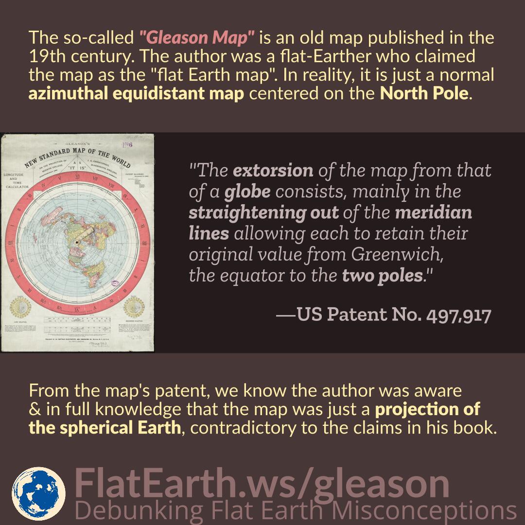
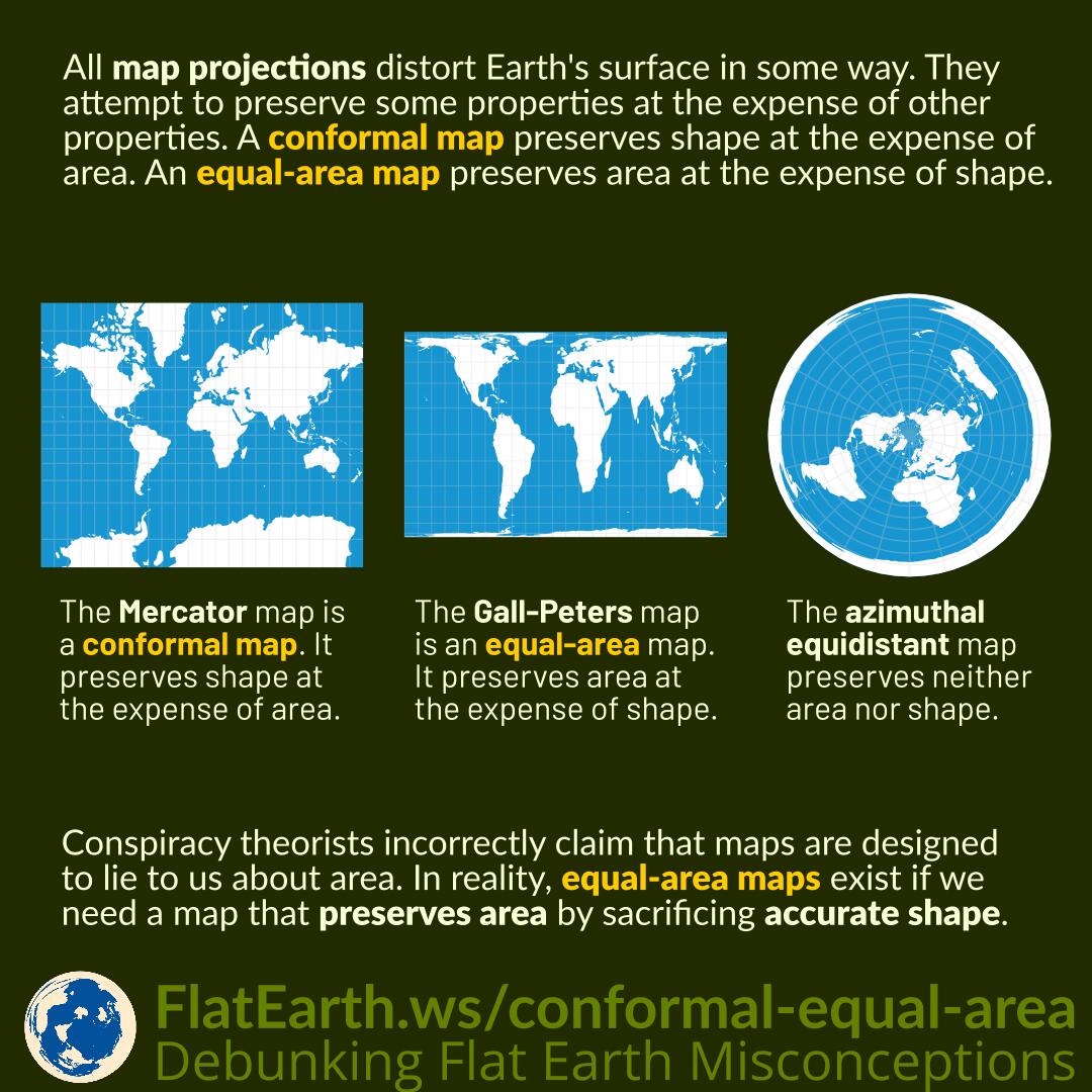
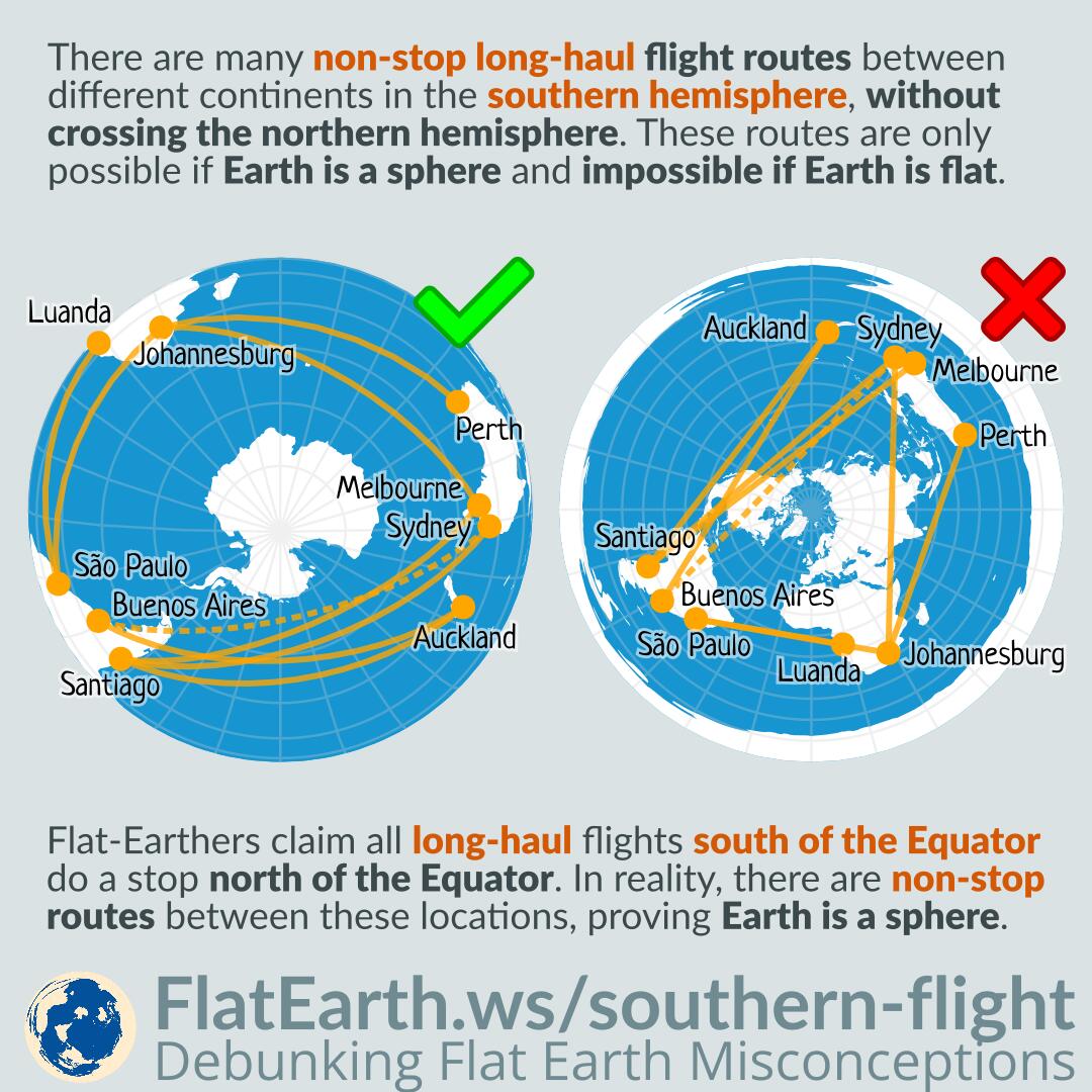
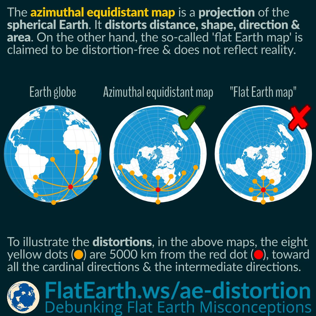
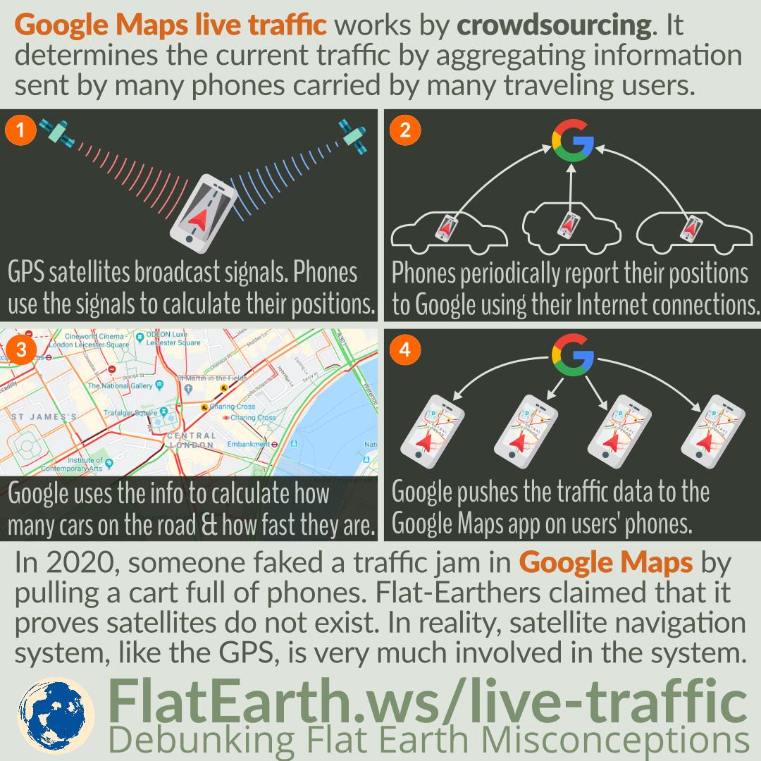
Google Maps live traffic works by crowdsourcing. It determines the current traffic by aggregating information sent by many phones carried by many different traveling users.

In February 2020, artist Simon Weckert successfully gamed the system and faked a traffic jam in Google Maps. He did that by pulling a cart full of active phones and walking in the middle of roads. Google Maps system thought there were many slow-moving cars on the road and regarded that as a traffic jam. As a result, during Simon’s operation, an empty road appeared as dark red in Google Maps, as if a traffic jam was ongoing.

Flat-Earthers claimed that it proves that satellites do not exist; possibly because they did not know how the system works. It might be that they previously thought the traffic data was obtained directly from satellite imagery. In reality, satellite navigation systems, like the GPS, is very much involved in the system.

Continue reading “Google Maps Live Traffic and Simon Weckert’s Virtual Traffic Jam”

Air Map of the World 1943/1945

Flat-Earthers discovered a map titled “Air Map of the World” from 1943, explaining the flight routes during the time. Because the shape is identical to the fictional “flat Earth map,” they incorrectly claimed that it is a flat-Earth map. In reality, it is an azimuthal equidistant map that has distortions, a flattened shape of the spherical Earth on a flat surface, and does not depict the true shape of the Earth.

The exact nature of the map is even explained in a very detailed manner in the map’s description. Unfortunately, in the flat-Earth community, the map is passed around in a very low resolution, and therefore, the explanations become unreadable.

Continue reading “Air Map of the World 1943/1945”