
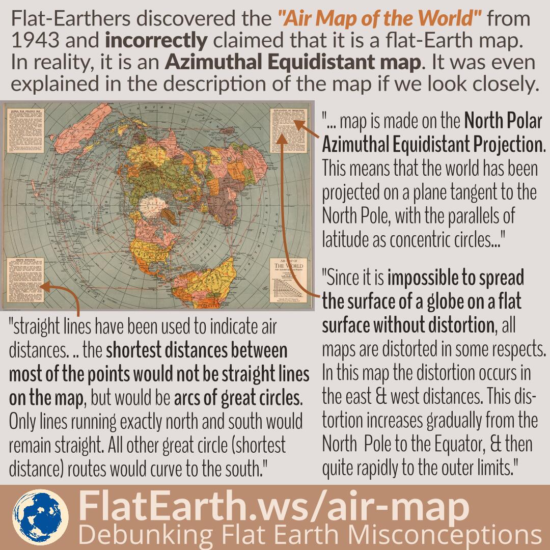
Flat-Earthers discovered a map titled “Air Map of the World” from 1943, explaining the flight routes during the time. Because the shape is identical to the fictional “flat Earth map,” they incorrectly claimed that it is a flat-Earth map. In reality, it is an azimuthal equidistant map that has distortions, a flattened shape of the spherical Earth on a flat surface, and does not depict the true shape of the Earth.
The exact nature of the map is even explained in a very detailed manner in the map’s description. Unfortunately, in the flat-Earth community, the map is passed around in a very low resolution, and therefore, the explanations become unreadable.
Table of Contents
High-Resolution Version
(click to get the high-resolution version)
Transcript from the Upper Left Box
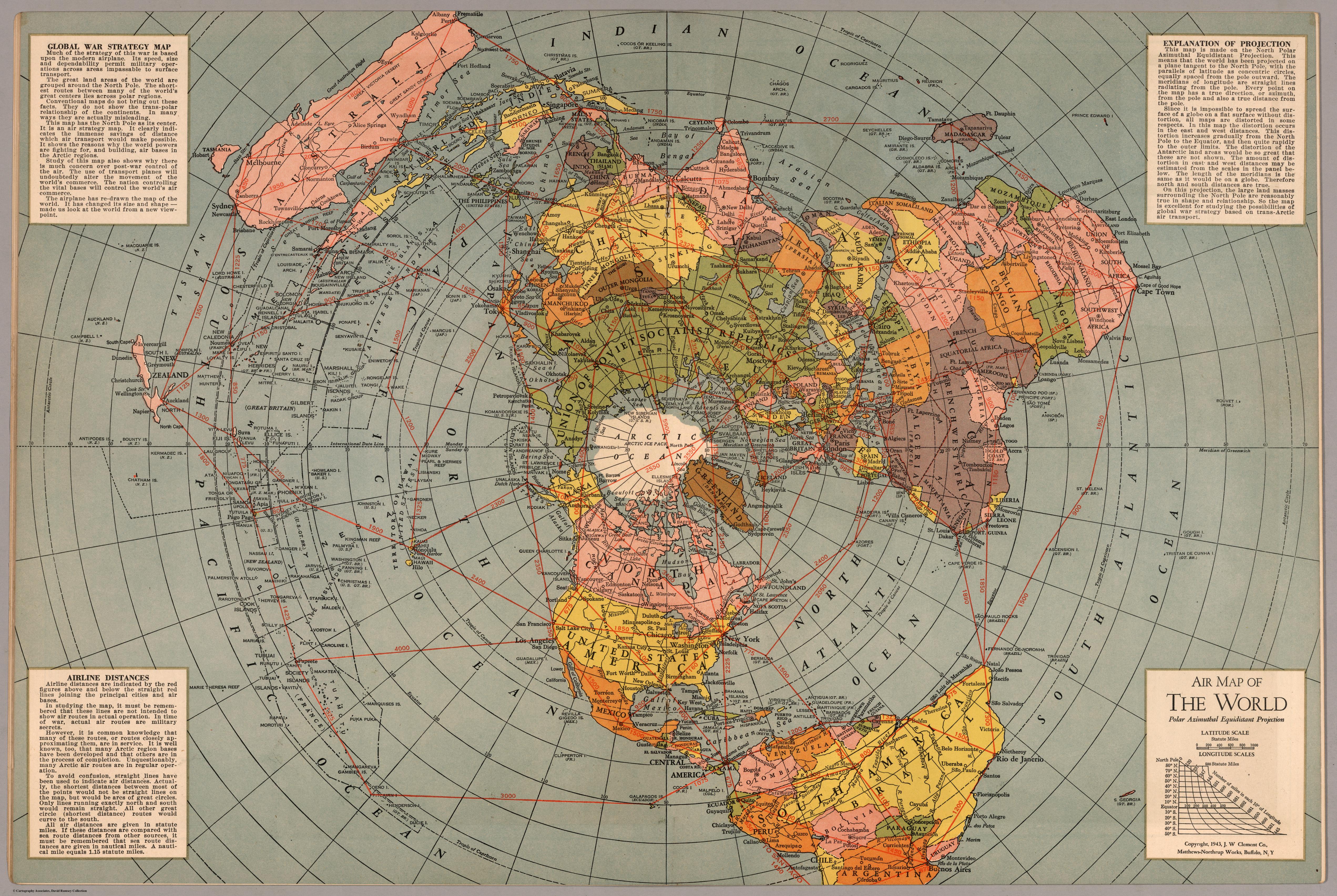
GLOBAL WAR STRATEGY MAP
Much of the strategy of this war is based upon the modern airplane. Its speed, size and dependability permit military operations across areas impassable to surface transport.
The great land areas of the world are grouped around the North Pole. The shortest routes between many of the world’s great centers lies across polar regions.
Conventional maps do not bring out these facts. They do not show the trans-polar relationship of the continents. In many ways they are actually misleading.
This map has the North Pole as its center. It is an air strategy map. It clearly indicates the immense savings of distance which air transport would make possible. It shows the reasons why the world powers are fighting for, and building, air bases in the Arctic regions.
Study of this map also shows why there is much concern over post-war control of the air. The use of transport planes will undoubtedly alter the movement of the world’s commerce. The nation controlling the vital bases will control the world’s air commerce.
The airplane has re-drawn the map of the world. It has changed its size and shape — made us look at the world from a new viewpoint.
Transcript from the Upper Right Box
EXPLANATION OF PROJECTION
This map is made on the North Polar Azimuthal Equidistant Projection. This means that the world has been projected on ta plane tangent to the North Pole, with the parallels of latitude as concentric circles, equally spaced from the pole outward. The meridians of longitude ar straight lines radiating from the pole. Every point on the map has a true direction, or azimuth, from the pole and also a true distance from the pole.
Since it is impossible to spread the surface of a globe on a flat surface without distortion, all maps are distorted in some respects. In this map the distortion occurs in the east and west distances. This distortion increases gradually from the North Pole to the Equator, and then quite rapidly to the outer limits. The distortion of the Antarctic land areas would be so great that these are not shown. The amount of distortion in east and west distances may be estimated from the scales in the panel below. The length of the meridians is the same as it would be on a globe. Therefore north and south distances are true.
On this projection, the large land masses surrounding the North Pole are reasonably true in shape and relationship. So the map is excellent for studying the possibilities of global war strategy based on trans-Arctic air transport.
Transcript from the Lower Left Box
AIRLINE DISTANCES
Airline distances are indicated by the red figures above and below the straight red lines joining the principal cities and air bases.
In studying the map, it must be remembered that these lines are not intended to show air routes in actual operation. In time of war, actual air routes are military secrets.
However it is common knowledge that many of these routes, or routes closely approximating them, are in service. It is well known, too, that many Arctic region bases have been developed and that others are in the process of completion. Unquestionably, many Arctic air routes are in regular operation.
To avoid confusion, straight lines have been used to indicate air distance. Actually, the shortest distances between most of the points would not be straight lines on the map, but would be arcs of great circles. Only lines running exactly north and south would remain straight. All other great circle (shortest distance) routes would curve to the south.
All air distances are given in statute miles. If these distances are compared with sea route distances from other sources, it must be remembered that sea route distances are given in nautical miles. A nautical mile equals 1.15 statue miles.