Skip to content
FlatEarth.ws

FlatEarth.ws

Debunking Flat Earth Misconceptions

  • 🏠
  • Special
    • Editorial
    • Basic Science
    • Easy Observations & Experiments
    • Analysis of the Flat Earth Model
    • Curvature Analysis
    • Rebuttals to Eric Dubay’s “200 Proofs”
  • A-C
    • Analogy
    • Antarctica
    • Astronomy
    • Atmosphere
    • Aviation
    • Buoyancy
    • CGI
    • Construction
    • Conspiracy Theory
    • Coriolis & Eötvös Effect
    • Curvature
  • D-L
    • Dip of the Horizon
    • Eclipse
    • Figure of the Earth
    • Fisheye
    • Geometry
    • Gravity
    • Gyroscope
    • Heliocentrism
    • Linguistics
  • M-O
    • Magnetism
    • Mapping
    • Measurement
    • Military
    • Moon
    • Moon Landing
    • Motion of the Earth
    • NASA
    • Navigation
    • Optical Phenomena
  • P-R
    • Perspective
    • Philosophy
    • Photography
    • Polaris
    • Lake Pontchartrain
    • Psychology
    • Public Figure
    • Quote Mining
    • Refraction
    • Relativity
    • River
  • S-W
    • Satellite
    • Solar System
    • Southern Facts
    • Space Flight
    • Stars
    • Sunrise & Sunset
    • Tide
    • Water
    • Weather & Climate
  • 文Ã
    • 🇸🇦🇯🇴 العربية
    • 🇪🇸🇲🇽 Español
    • 🇮🇩 Bahasa Indonesia
    • 🇮🇹 Italiano
    • 🇳🇱🇧🇪 Nederlands
    • 🇵🇹🇧🇷 Português
    • 🇷🇴 Română
    • Your language here…

Flag and Emblem of the United Nations

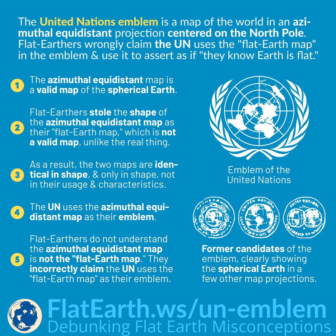
The flag and emblem of the United Nations is a map of the world in the azimuthal projection centered on the North Pole. Flat-Earthers wrongly claim that the UN uses the so-called “flat-Earth map” in their emblem and use it as “evidence” that the UN “knows Earth is flat.”

The azimuthal equidistant map is a perfectly valid map of the spherical Earth, and it is used for many purposes if the task at hand calls for it.

Some flat-Earthers noticed an azimuthal equidistant map centered on the North Pole and stole it as the shape of their own “flat-Earth map.” Unlike the map they are stealing from, the so-called “flat-Earth map” is not valid.  The real azimuthal equidistant map is just a projection of the spherical Earth on a 2D medium, while the so-called “flat-Earth map” is a scaled-down version of the purported “flat-Earth” and claimed to be distortion-free.

As a result, both the azimuthal equidistant map and the so-called “flat-Earth map” are identical in shape and only in shape, but not in their usage and characteristics.

The United Nations decided to use the azimuthal equidistant map centered as the North Pole as their emblem, which is not the so-called “flat-Earth map” but having the same shape.

Flat-Earthers cannot understand that the azimuthal equidistant map is different from the “flat-Earth map” and incorrectly claim the UN uses the “flat-Earth map” as their emblem.

When the United Nations first created its logo, there are several candidates to choose from. Some depict the Earth in different map projections and clearly show that the Earth is a sphere.

References

  • UN Logo and Flag – United Nations
  • The Architect Who Designed the UN Logo – United Nations Blog
  • Origin of the Emblem and other Recollections of the 1945 UN Conference – United Nations
  • Maps, Flags, and Boundaries – Research Guides at United Nations Dag Hammarskjöld Library
  • Origin of the Emblem and Other Recollections of the 1945 UN Conference – Donal McLaughlin

Share this:

  • Click to share on Twitter (Opens in new window)
  • Click to share on Facebook (Opens in new window)
  • Click to share on Reddit (Opens in new window)
  • Click to share on Tumblr (Opens in new window)
  • Click to share on Pinterest (Opens in new window)
  • Click to share on Telegram (Opens in new window)
  • Click to share on WhatsApp (Opens in new window)
  • Click to print (Opens in new window)
CategoriesConspiracy Theory, Mapping Tagsazimuthal-equidistant, equidistant, logo, map-projection, orthographic, projection, un, united-nations

Post navigation

Previous PostPrevious Fallacy of Appeal to Worse Problems / Relative Privation
Next PostNext Gravitational Acceleration in Archimedes’ Formula

Become a Patron

Like on Facebook

Follow on Instagram

Download all our images

Other Sites

  • Flat Earth Busted
  • Flat Earth @Metabunk
  • More than 200 proofs that the Earth is not Flat
  • Flat Earth Lunacy
  • Everyday Science (@kerriknox)
  • MCToon

Recommended YouTube Channels

  • Soundly
  • Wolfie6020
  • Sly Sparkane
  • SciManDan
  • Professor Dave Explains
  • GreaterSapien
  • Reds Rhetoric
  • CoolHardLogic
  • Tau Ceti Alpha

Toolbox

  • Cartography
    • Google Earth
    • Worldmap Generator
    • Worldmap Creator
    • Great Circle Mapper – 1
    • Great Circle Mapper – 2
    • Metabunk Flat Earth Route Simulator
    • G.Projector
    • The True Size of …
    • topographic-map.com
  • Curvature
    • Earth Curvature Calculator
    • Earth Curvature Calculator
    • Metabunk Earth Calculator
    • FEI Horizon Calculator
    • Earth Curvature Simulation – Walter Bislin
    • GeoGebra Horizon Calculator
    • Wireless Elevation Tool
  • Astronomy / Satellites
    • Stellarium Web
    • Space-Track.org
    • ESRI Satellite Map
    • SpaceBook
    • Centre de Données astronomiques de Strasbourg
    • Transit Finder
    • Heavens Above
  • Miscellaneous
    • Camera & Lens FoV Calculator
    • SunCalc
    • timeanddate.com
    • 3D Sun Path