How GPS and Other Satellite Navigation System Work

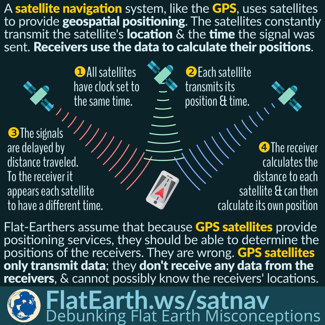
A satellite navigation or satnav system is a system that uses satellites to provide autonomous geo-spatial positioning. Several satellites continuously transmit signals containing their positions and the time when the signal was sent. Receiver units listen to the signals and use the information to calculate their positions.

Flat-Earthers assume that if GPS satellites are used to determine positions, then they should be able to pinpoint the position of a receiver. They are wrong. GPS satellites only transmit signals but never receive signals from the receivers. It is impossible for the satellites to determine the position of a receiver.

Continue reading “How GPS and Other Satellite Navigation System Work”

Ring Laser Gyroscopes are Sensitive Enough to Measure Earth’s Rotation

A ring laser gyroscope (RLG) is an instrument for measuring the change in orientation and rotational velocity. It is sensitive enough to measure Earth’s rotation easily.

Flat-Earthers claim that there is no instrument able to measure Earth’s rotation. Such claim arose from their ignorance. Ring laser gyroscopes —which are installed in some airplanes and ships— can easily detect and measure Earth’s rotation.

Continue reading “Ring Laser Gyroscopes are Sensitive Enough to Measure Earth’s Rotation”

Range Estimation Using the Distance to the Horizon

Sailors sometimes need to estimate the range of a distant contact. Without radars, the only readily available reference point for estimating ranges is the horizon.

By knowing the height of the observer from the waterline, it is possible to calculate the distance to the horizon, and thus, it is possible to determine the distance to a remote contact, relative to the horizon. It is possible to do this only because the Earth is spherical.

Continue reading “Range Estimation Using the Distance to the Horizon”

The Taiwan–Los Angeles Flight (not from Bali) that was Diverted to Anchorage

There was a flight from Taiwan to Los Angeles that was diverted to Anchorage because one of the passengers gave birth to a baby. Flat-Earthers use the case as one of the first “evidence” from flight routes proving Earth is flat.

They are wrong. The case only tells us about the ignorance of these flat-Earthers about the distortion in a map projection. Their argument started with an elementary mistake of taking a straight line on a Mercator map between Taiwan and Los Angeles, and assume it as the “intended flight path.”

Continue reading “The Taiwan–Los Angeles Flight (not from Bali) that was Diverted to Anchorage”

The Failure of Flat-Earth Model to Explain Emergency Landings That Occur More to the South

The perpetrators of flat-Earth often take emergency landings as ‘proof’ of a flat Earth. They would point out that the diversion airports used for such emergency landings are somehow consistent with the flat-Earth map.

It is not a coincidence that all the cases of emergency landing they pointed out occurred far in the north. At the locations closer to the north pole, the distortion of the azimuthal-equidistant map (claimed by flat-Earthers as the ‘flat-Earth map’) diminishes. It would seemingly appear as if the ‘flat-Earth map’ can explain the choice of the diversion airports. In many other locations, though, the flat-Earth map would fail to explain it.

Continue reading “The Failure of Flat-Earth Model to Explain Emergency Landings That Occur More to the South”

Crow’s Nest on Ships

A crow’s nest is a structure in the upper part of the ship, especially old-fashioned ones. It is used as a lookout point and positioned high above to increase visibility over the curvature of the Earth.

On the deck of a ship 4 m (13 ft) above the surface of the ocean, an observer can spot a 20 m (66 ft) high ship from at most ±25 km (16 mi). On the other hand, from a 35 m (115 ft) high crow’s nest, an observer will be able to spot the same ship from ±40 km (25 mi) away.

Continue reading “Crow’s Nest on Ships”

Sextant: Determining Latitude from The Positions of the Stars

Long before GPS, navigators used a device called ‘sextant’ to determine the angle of a celestial body. From that data, the latitude of their current location can be determined.

This can only happen if the Earth is spherical.

Continue reading “Sextant: Determining Latitude from The Positions of the Stars”

Google Maps, GPS and Cellular Signal Reception

Google Maps and similar apps use satellite navigation —like the GPS— to determine the location of the device. The apps also utilize cellular data or other data connection to obtain map and route data, which are not part of the GPS or satellite navigation system.

Some flat-Earthers noticed that Google Maps does not fully function when the cellular signal is not available. They concluded that GPS signals are transmitted by cell towers, not satellites. In reality, Google Maps is not GPS. The app uses GPS —and other satnav systems— to determine user location. The maps and route data in the apps are not part of the GPS.

Continue reading “Google Maps, GPS and Cellular Signal Reception”

Polaris – The North Star

To most flat-earthers, the Earth is stationary. Stars are light sources attached to the firmament (for some mysterious reason), and they rotate around Polaris (again, for some mysterious reason).

However, they are missing the fact that Polaris is never visible from the southern hemisphere. And furthermore, the southern stars also rotate around the south celestial pole.

Continue reading “Polaris – The North Star”