
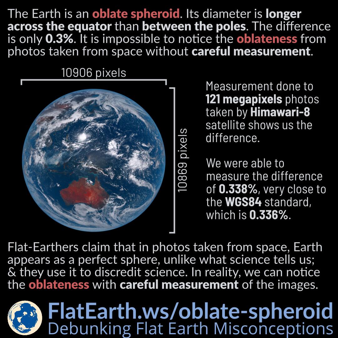
The Earth is an oblate spheroid. Its diameter is longer across the equator than between the poles. The difference is tiny, only about 0.3%. It is not possible to notice the oblateness from photographs taken from space without careful measurement.
Flat-Earthers claim that in photos taken from space, Earth appears as a perfect sphere, unlike what science tells us, and they use it to discredit science. In reality, it is possible to notice the oblate shape with careful measurement of the images.
The Himawari satellite produces images of the entire Earth in a very high resolution: 121 megapixels. It is possible to use the images to measure the oblateness of the Earth, where it is harder to do on lower resolution images. We were able to measure the difference of 0.338%, very close to the WGS84 standard, which is 0.336%.
Table of Contents
Our Measurement
We used satellite images from Himawari-8. The resolution of the pictures is 11000×11000, or 121 megapixels, which should be sufficient. For this purpose, we have to find pictures that show the visible part of the Earth perfectly illuminated by the Sun. We were able to find these four matching images:
- hima820150923112000fd.png: 10906×10868
- hima820160320112000fd.png: 10905×10870
- hima820160923112000fd.png: 10906×10869
- hima820170922112000fd.png: 10906×10869
The number after the filenames are the size of the Earth in the corresponding images in pixels. The average size is 10905.75×10869. And the difference is 0.338%.
According to the measurements, we can determine that the Earth is, in fact, oblate spheroid. Its diameter across the equator is longer than between the poles. The number is also very close to the difference of the diameters in the WGS84 standard, which is 0.336%.
In conclusion, it is possible to measure that Earth an oblate spheroid from photos taken from space, and the difference between its diameters is also very close to the expected number.
The detailed description of our analyses follows.
Finding Suitable Images
We need images that show the visible part of the Earth fully illuminated by the Sun, so we can easily measure horizontal and vertical distance in the pictures.
Himawari-8 is a geostationary satellite. It is always above the equator on a constant longitude. With that in mind, we need to find images taken when it is noon during the equinox.
After perusing Himawari-8’s database, we were able to find four suitable images:
- hima820150923112000fd.png
- hima820160320112000fd.png
- hima820160923112000fd.png
- hima820170922112000fd.png
Unfortunately, during March 2017 equinox, Himawari-8 didn’t produce any image.
Analysis
To perform an analysis of the images, we used a shell script with ImageMagick. The goal is to apply the same processing to all photos and to avoid subjective biases. The following is the script we used.
#!/bin/sh

for A in *.png ; do
        echo $A
        convert $A -fuzz 30% -trim +repage -format 'scale=5; %w ; %h; (%w / %h)
- 1\n' info: | bc
done
The script crops the images to remove the black borders around Earth then determines the dimensions of the results and calculates their difference.
Reference
- Figure of the Earth – Wikipedia
- World Geodetic System – Wikipedia
- Earth ellipsoid – Wikipedia
- Himawari-8 Real Time – NICT
- ImageMagick