Visualization of Satellites and Space Debris

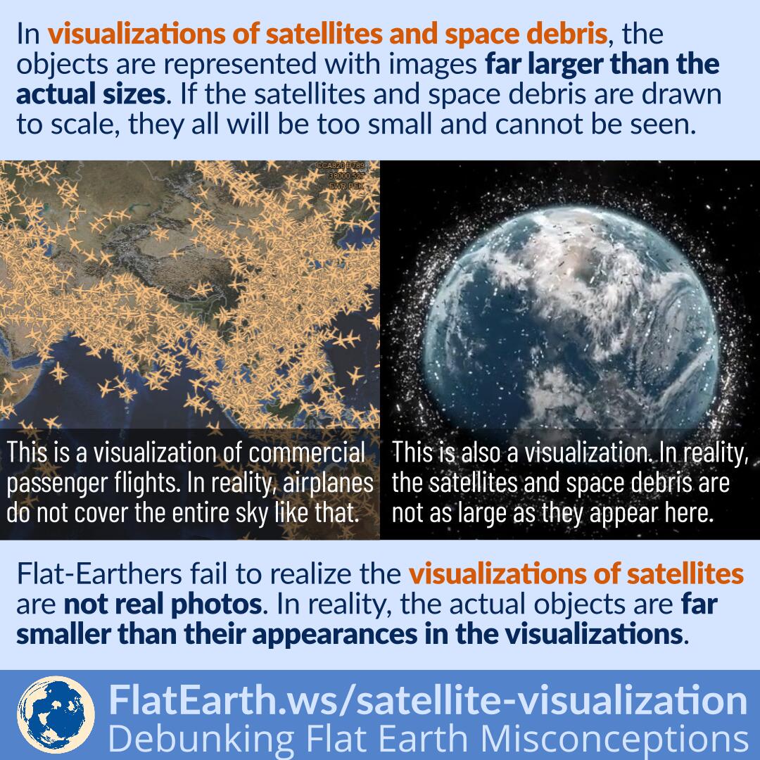
Various pictures showing satellites and space debris around the Earth are visualizations. They are not real photos taken from cameras. These visualizations were created by drawing the objects with sizes far larger than their actual dimensions. If they were drawn to scale, then they all will be too small and cannot be seen in the visualizations.

Flat-Earthers fail to realize that these are visualizations. They think the pictures are presented as real photos. Because we never see satellites like that, they concluded that it was a deception. In reality, these pictures are simply visualization, not actual photos.

Continue reading “Visualization of Satellites and Space Debris”

How GPS and Other Satellite Navigation System Work

A satellite navigation or satnav system is a system that uses satellites to provide autonomous geo-spatial positioning. Several satellites continuously transmit signals containing their positions and the time when the signal was sent. Receiver units listen to the signals and use the information to calculate their positions.

Flat-Earthers assume that if GPS satellites are used to determine positions, then they should be able to pinpoint the position of a receiver. They are wrong. GPS satellites only transmit signals but never receive signals from the receivers. It is impossible for the satellites to determine the position of a receiver.

Continue reading “How GPS and Other Satellite Navigation System Work”

White Alice and the Troposcatter Propagation

Troposcatter is a signal propagation method using the scattering phenomenon in the upper troposphere. As the signal pass through the upper troposphere, some of the energy is scattered back toward Earth, allowing the receiver station at the correct location to pick up the signal.

White Alice is a decommissioned troposcatter network in North America. Some flat-Earthers invented the “explanation” that the various satellite-based services we enjoy today are using White Alice. They are wrong. White Alice and other troposcatter networks cannot possibly replace all the services provided by satellites.

Continue reading “White Alice and the Troposcatter Propagation”

Orbital Station-Keeping

A satellite in a high enough orbit can remain operational for a very long time because in space there is practically no air resistance. This is a situation that never occurs in our everyday life. A car requires a constant consumption of fuel to keep running, but a satellite can remain in motion without consuming any fuel because there’s practically no force stopping it.

Flat-Earthers claim that satellites cannot stay up there for such a very long time because ‘we never refuel any satellites.’ They are wrong. In space, there is practically no drag, and satellites only need to consume fuel to adjust their speed periodically.

Continue reading “Orbital Station-Keeping”

Observing the ISS from ISS Transits

Flat-Earthers reject the existence of satellites. They are wrong. To prove the existence satellites, we can attempt to take pictures of the ISS when an ISS transit happens, or the ISS passes in front of the Sun or the Moon.

Continue reading “Observing the ISS from ISS Transits”

Iridium Flare

Iridium is a satellite constellation consisting of 66 satellites. It provides satellite phone services over the entire Earth surface. The first generation satellites have three door-sized reflective antennas. Because of their reflectivity, Iridium satellites will occasionally reflect sunlight to Earth’s surface. The Iridium flare will look like a bright flash over a few seconds.

Most flat-Earthers deny the existence of satellites. Iridium flares provide an easy opportunity to confirm the existence of satellites, at least until the end of 2018, when they are replaced by newer non-reflecting satellites.

Continue reading “Iridium Flare”

Why Don’t We See Satellites in Photos Taken From The ISS?

“Why don’t we see satellites in photos taken from the ISS?” (or from space in general). That’s a recurring question within the flat-Earth community, usually asked without expecting an answer, assuming that an answer is impossible, and that it is a glaring oversight when the powers that be purposefully made the picture using CGI.

But no, the pictures are real. And satellites are not visible because they are too far spaced apart from each other.

Continue reading “Why Don’t We See Satellites in Photos Taken From The ISS?”

Space Flight and the Temperature in the Thermosphere

The thermosphere is a layer of the Earth’s atmosphere from about 95 km­ to 600 km. It is named ‘thermosphere’ because its temperature increases with altitude. The temperature in the thermosphere can reach 2500°C. However, air density in the thermosphere is very low to the point that heat conduction practically does not occur. Objects in the thermosphere will feel cold.

Flat-Earthers discovered that the temperature in the thermosphere could reach 2500°C. They are happy to ignore the other information which usually accompanies it: the air density up there is also far lower.

Continue reading “Space Flight and the Temperature in the Thermosphere”

Google Maps, GPS and Cellular Signal Reception

Google Maps and similar apps use satellite navigation —like the GPS— to determine the location of the device. The apps also utilize cellular data or other data connection to obtain map and route data, which are not part of the GPS or satellite navigation system.

Some flat-Earthers noticed that Google Maps does not fully function when the cellular signal is not available. They concluded that GPS signals are transmitted by cell towers, not satellites. In reality, Google Maps is not GPS. The app uses GPS —and other satnav systems— to determine user location. The maps and route data in the apps are not part of the GPS.

Continue reading “Google Maps, GPS and Cellular Signal Reception”