Why It is Difficult for Satellites to Locate the Missing MH370 Flight

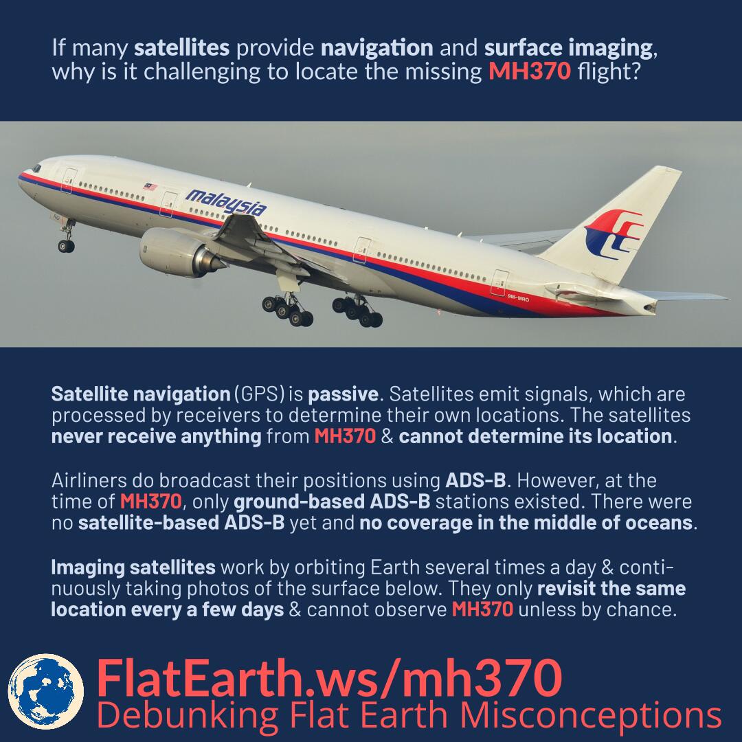
If many satellites provide navigation and surface imagery, why is it challenging to locate the missing MH370 flight?

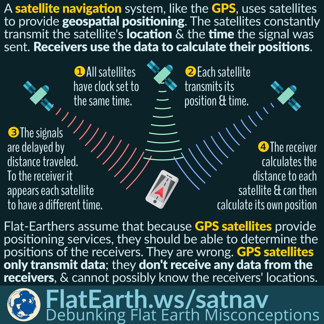
Satellite navigation, including GPS, is passive. Satellites emit signals, which are processed by receivers —including those on board the MH370— to determine their own locations. The satellites never receive anything from MH370 and cannot determine its location.

Airliners do broadcast their positions using ADS-B. However, at the time of MH370, only ground-based ADS-B stations existed. There were no satellite-based ADS-B receivers yet, and no coverage in the middle of oceans.

Continue reading “Why It is Difficult for Satellites to Locate the Missing MH370 Flight”

Location Crowdsourcing

In addition to satellite navigation, mobile phones can also use crowdsourced cell sites and WiFi access points location data. Phones help each other by creating a centralized database of the locations of cell sites and WiFi access points. If satellite navigation is unavailable, then the phones can utilize this database to determine their positions.

Some documentations explain how a phone or device without GPS can determine its location. Flat-Earthers incorrectly use these documentations to “prove” GPS does not use satellites. In reality, there are various methods of determining location, not just GPS. These documentations explain location service using cell & WiFi crowdsourcing, which is different from GPS.

Continue reading “Location Crowdsourcing”

Google Maps Live Traffic and Simon Weckert’s Virtual Traffic Jam

Google Maps live traffic works by crowdsourcing. It determines the current traffic by aggregating information sent by many phones carried by many different traveling users.

In February 2020, artist Simon Weckert successfully gamed the system and faked a traffic jam in Google Maps. He did that by pulling a cart full of active phones and walking in the middle of roads. Google Maps system thought there were many slow-moving cars on the road and regarded that as a traffic jam. As a result, during Simon’s operation, an empty road appeared as dark red in Google Maps, as if a traffic jam was ongoing.

Flat-Earthers claimed that it proves that satellites do not exist; possibly because they did not know how the system works. It might be that they previously thought the traffic data was obtained directly from satellite imagery. In reality, satellite navigation systems, like the GPS, is very much involved in the system.

Continue reading “Google Maps Live Traffic and Simon Weckert’s Virtual Traffic Jam”

How GPS and Other Satellite Navigation System Work

A satellite navigation or satnav system is a system that uses satellites to provide autonomous geo-spatial positioning. Several satellites continuously transmit signals containing their positions and the time when the signal was sent. Receiver units listen to the signals and use the information to calculate their positions.

Flat-Earthers assume that if GPS satellites are used to determine positions, then they should be able to pinpoint the position of a receiver. They are wrong. GPS satellites only transmit signals but never receive signals from the receivers. It is impossible for the satellites to determine the position of a receiver.

Continue reading “How GPS and Other Satellite Navigation System Work”

Sextant: Determining Latitude from The Positions of the Stars

Long before GPS, navigators used a device called ‘sextant’ to determine the angle of a celestial body. From that data, the latitude of their current location can be determined.

This can only happen if the Earth is spherical.

Continue reading “Sextant: Determining Latitude from The Positions of the Stars”

Google Maps, GPS and Cellular Signal Reception

Google Maps and similar apps use satellite navigation —like the GPS— to determine the location of the device. The apps also utilize cellular data or other data connection to obtain map and route data, which are not part of the GPS or satellite navigation system.

Some flat-Earthers noticed that Google Maps does not fully function when the cellular signal is not available. They concluded that GPS signals are transmitted by cell towers, not satellites. In reality, Google Maps is not GPS. The app uses GPS —and other satnav systems— to determine user location. The maps and route data in the apps are not part of the GPS.

Continue reading “Google Maps, GPS and Cellular Signal Reception”