Orbit of DSCOVR Satellite

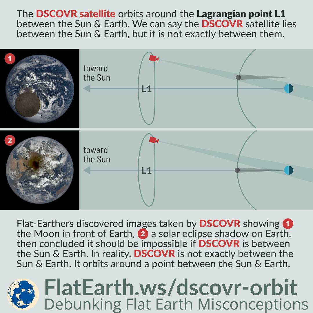
The DSCOVR satellite orbits around the Lagrangian point L1 between the Sun and Earth. We can say the DSCOVR satellite lies between the Sun and Earth, but it is not exactly between them.

Flat-Earthers discovered images taken by the DSCOVR satellite showing the Moon in front of Earth and a solar eclipse shadow on Earth’s surface. Then they concluded it should be impossible if DSCOVR is really between the Sun and Earth. In reality, the DSCOVR satellite is not exactly between the Sun and Earth. It orbits a point between the Sun and Earth.

Continue reading “Orbit of DSCOVR Satellite”

Lunar Transit Images from DSCOVR-EPIC

Featured Video Play Icon

DSCOVR is a spacecraft positioned in the Lagrangian point L1 between the Sun and Earth. It carries the EPIC camera that continuously takes images of Earth in 10 wavelengths from 317nm to 780 nm in rotation.

The Moon can appear in EPIC images, and flat-Earthers incorrectly use the color fringing around the Moon to dismiss the images as fake. In reality, the full-color images are composite of three single-color images taken in consecutive exposures in a one-minute span. As a result, the Moon had shifted in the time span and not perfectly aligned in the different exposures, causing the color-fringing after the images are composited together.

Continue reading “Lunar Transit Images from DSCOVR-EPIC”

Earth’s Rotation in Videos Taken From Space

Featured Video Play Icon

The Earth rotates only once every 24 hours. To notice the rotation of Earth in a video taken from space, we need to speed up the video so that it appears fast enough for us to notice it. We also need to make sure the video was taken from a spacecraft where its motion does not dominate over the movement of Earth itself.

Flat-Earthers claim that videos taken from space were faked because the Earth does not appear rotating. In reality, Earth rotates far too slowly to be casually seen without increasing the speed.

Continue reading “Earth’s Rotation in Videos Taken From Space”

Real Photos of the Earth

The first photo showing the entire Earth was taken in 1966 from the spacecraft Lunar Orbiter 1. Since then, there are too many photos showing the whole earth taken from various missions to space.

The advent of computers in the 80s introduced a new technique of generating such pictures. A satellite can be used to take many photos of the Earth from a low orbit, and computers can be used to assemble those pictures into a single photo of the Earth.

Flat-Earthers ‘discovered’ such technique, then they concluded that all pictures of the Earth taken from space are all composites, the results of manipulation or assembled by computers. They are wrong. Just because there were pictures created using such technique, it doesn’t mean there is no genuine picture showing the entire Earth, not composites, not stitched, and were taken from a single shot.

Continue reading “Real Photos of the Earth”