Authagraph Map Projection

Featured Video Play Icon

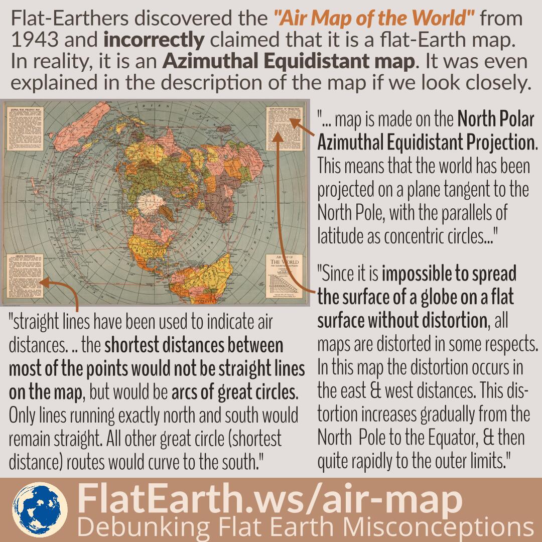
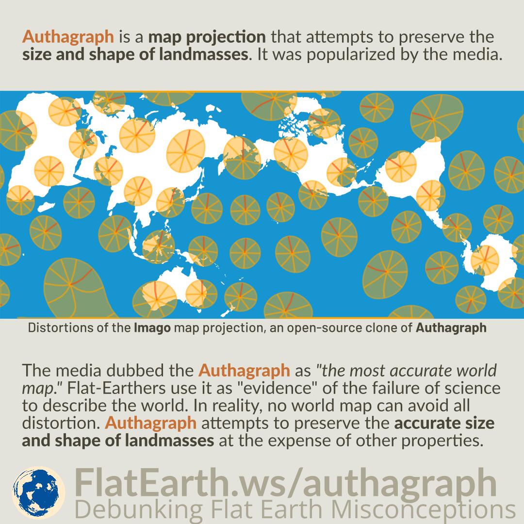
Authagraph is a map projection that attempts to preserve the size and shape of landmasses. It was popularized by the media.

The media dubbed the Authagraph as “the most accurate world map.” Flat-Earthers use it as “evidence” of the failure of science to describe the world. In reality, no world map can avoid all distortion. Authagraph attempts to preserve the accurate size and shape of landmasses at the expense of other properties.

Continue reading “Authagraph Map Projection”

The Polar Azimuthal Equidistant Map is NOT the Flat Earth Map

The azimuthal equidistant map is a projection of spherical Earth on a two-dimensional medium. The map has distortions, like every other type of map.

Flat-Earthers stole the shape of the azimuthal equidistant map and call it the “flat-Earth map.” While the two are identical in shape, they have different characteristics. The map that they call the “flat Earth map” is claimed to be a scaled-down representation of the supposed flat earth. They claim it to be distortion-free.

Some institutions use the azimuthal equidistant map & flat-Earthers incorrectly claim it as an “endorsement” of flat Earth. These maps are azimuthal equidistant maps and not related to flat Earth.

Continue reading “The Polar Azimuthal Equidistant Map is NOT the Flat Earth Map”

Fisheye Lenses and Lens Distortions

Featured Video Play Icon

A photographic lens may have a specific distortion characteristic and strength that may differ from another lens. However, despite the differences, a straight line will always appear straight if it crosses the center of the frame.

Flat-Earthers like to dismiss images taken by a fisheye lens. In reality, the attributes of such a lens are well known. We can use the knowledge to determine if a line in the image is straight, even if it was taken using a fisheye lens.

Continue reading “Fisheye Lenses and Lens Distortions”

Defishing Fisheye Images Excessively to Flatten the Curved Horizon

Defishing is a process for removing barrel distortions from fisheye images, producing rectilinear images that preserve straight lines. A different fisheye lens produces a different amount of distortion & needs a different defishing strength.

Flat-Earthers like to apply a stronger defishing parameter than necessary with the goal not to remove the distortions but to make the horizon flat. As a result, they not only remove barrel distortion from the image but also introduce pincushion distortion that straightens the curved horizon.

The horizon in the end image might appear flat. However, it is due to the distortion these flat-Earthers deliberately introduced to the image, not because the horizon is flat.

Continue reading “Defishing Fisheye Images Excessively to Flatten the Curved Horizon”

Gleason Map

The so-called “Gleason Map” is an old map published in the 19th century. The author was a flat-Earther who claimed the map as the “flat Earth map.” In reality, the map is just a normal azimuthal equidistant map centered on the North Pole.

From the map’s patent, we know the author was aware and in full knowledge that the map was just a projection of the spherical Earth, contradictory to the claims in his book.

Continue reading “Gleason Map”

Conformal vs Equal-Area Map

All map projections distort Earth’s surface in some way. They attempt to preserve some properties at the expense of other properties. A conformal map preserves shape at the expense of area. On the other hand, an equal-area map preserves area at the expense of shape.

Conspiracy theorists incorrectly claim that maps are designed to lie to us about the real area of countries. In reality, equal-area maps exist if we need a map that preserves area by sacrificing accurate shape.

Continue reading “Conformal vs Equal-Area Map”

Why Fisheye Lenses Are Used

Cameras with a fisheye lens are used in the ISS, high-altitude balloons, rocket bodies, and other purposes. The reason is that fisheye lenses have several advantages over rectilinear lenses.

Flat-Earthers claim there is an evil intention behind the usage of fisheye lenses. In reality, the use of fisheye lenses is not unreasonable. If it is desired to have a rectilinear image output, then it is not hard to defish fisheye images to rectilinear ones..

Continue reading “Why Fisheye Lenses Are Used”

Center of the Azimuthal Equidistant Map Projection

Featured Video Play Icon

Flat-Earthers copied the shape of the azimuthal equidistant map centered on the North Pole and claim it as their “flat-Earth map.” The real azimuthal equidistant map is not the so-called “flat-Earth map, and not necessarily centered on the North Pole.

On the azimuthal equidistant map, all points on the map are at proportionally correct distances from the center point, but only from the center point. Other distances are distorted.

Continue reading “Center of the Azimuthal Equidistant Map Projection”

Blue Marble and the Visible Area of Earth’s Surface

The Blue Marble is an image of Earth taken by the crew of the Apollo 17 spacecraft on its way to the Moon. It was taken from a distance of 29000 km from Earth’s surface.

Flat-Earthers dismiss it by incorrectly asserting that the image covers a too-small area of Earth’s surface, due to their failure to account for the maps’ distortion.

Continue reading “Blue Marble and the Visible Area of Earth’s Surface”

Air Map of the World 1943/1945

Flat-Earthers discovered a map titled “Air Map of the World” from 1943, explaining the flight routes during the time. Because the shape is identical to the fictional “flat Earth map,” they incorrectly claimed that it is a flat-Earth map. In reality, it is an azimuthal equidistant map that has distortions, a flattened shape of the spherical Earth on a flat surface, and does not depict the true shape of the Earth.

The exact nature of the map is even explained in a very detailed manner in the map’s description. Unfortunately, in the flat-Earth community, the map is passed around in a very low resolution, and therefore, the explanations become unreadable.

Continue reading “Air Map of the World 1943/1945”

Fisheye Videos

Featured Video Play Icon

In images taken using a fisheye lens, a straight line will remain straight if it crosses the center of the image. We can use this attribute to determine if a line is straight in reality.

In any fisheye videos taken from a high altitude, there should be plenty of moments where the horizon crosses the center of the image, and we can use those to determine that the horizon line is curved in the real world.

Continue reading “Fisheye Videos”

Day and Night Areas on a Flat Earth

Featured Video Play Icon

At any given time, there is an equal area of the Earth that is experiencing daytime, and that is having a night time. The reason is that the sun is very far, and it would illuminate a hemisphere of the Earth, and leave the other dark.

If we plot which areas of the Earth that are getting sunlight on an azimuthal equidistant map centered on the north pole, the sun would appear to illuminate a somewhat elliptical area during the northern hemisphere summer, and a lopsided Bat-Signal shaped area during the winter. During the equinox, the sun would appear to illuminate a half-circle area.

Continue reading “Day and Night Areas on a Flat Earth”